
Under Construction

|
|
Beechgrove Beach Under Construction |
|
![]()
This page has not been updated recently. It will be revised in 2002. The new additions are on the top of the list.
Additional Beechgrove information can be found HERE.
Directions to the beach are HERE.
![]()
Go to map of the beach area - March 2, 1999.
Go to NEW Beechgrove Photos - September/October 1998.
Go to - An Invitation to Comment on the Environmental Assessment for the Port Union Waterfront Improvements for the City of Toronto - January 1999.
Go to - comments on the beach by Fred - July 1998.
This year's Beechgrove Beach Cleanup Day was Sunday, June 7th, which was also World Naturist Day!!!
Go to - comments on the beach by Ron Schout - May 1998.
Go to - short letter regarding the Port Union Waterfront Improvement Project.
Go to - information on the public meeting scheduled for MARCH 4TH, 1998.
Go to - comments on the beach construction by Fred B/Toronto
Go to - comments on the beach construction by Phil M.
Click HERE if you would like to contribute to the FCN Free Beach Fund.
![]()
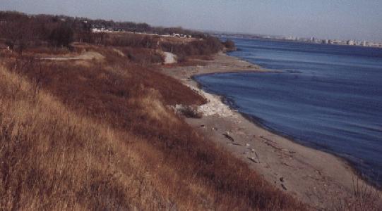
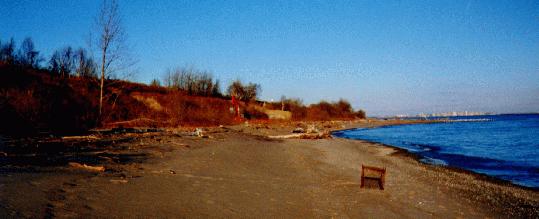
| Beechgrove Beach from the water. |
 |
Beechgrove Entrance |  |
Parking Lot |
This is Beechgrove Beach on the shores of Lake Ontario in Toronto, Canada. A waterfront trail has been planned along this beach which will destroy a lot of the vegetation on the slopes to make room for a walking trail. The current trail being constructed is being used for construction equipment at the present time.
![]()
 Pictures of the beach
If you have any pictures of Beechgrove Beach, please send them via the Photo Gallery page. Thanks.
To see a larger version of the photo, click on the picture shown.
Size of the larger photo is shown as (Size:xxKB).
Note: most recent pictures will be at the top.
 |
Last year (1997) at the beach. (Size:19KB) |
 |
Last year (1997) at the beach. (Size:14KB) |
 |
This is a picture of the proposed shoreline from the city plans of the beach. Note: the path is a narrow strip of white along the edge of the hill and away from the beach just below the dark area. The strange loops you see on the beach to the right are additions to the beach that are going to be built right out into Lake Ontario, to provide a path as the only access to that area, at the present time, is climbing large rocks. Highland Creek is on the left and the naturist beach is to the right of the creek outlet. (Size:43KB) |
 |
This is a detailed picture of the proposed shoreline from the city plans of the beach. It shows the Highland Creek Trail with the bridge across the Creek to the North (right) beach. This north beach is currently being used by the naturists. The CN tracks are in the middle of the picture. (Size:84KB) |
 |
This is a the same picture as the previous one but shows more of the beach area. (Size:68KB) |
 |
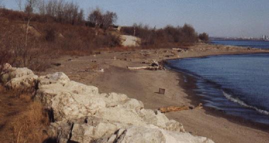
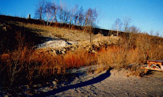
The path down to the beach before construction. It was very hard to get down to the beach and the hillside was covered in a lot of brush. The only time the beach was cleaned up was by the naturist beachgoers once or twice a year, which is evident by the amount of debris on the beach. (The hill in the picture has been lightened a lot in order to get a better view of it). (Size:28KB) |
 |
The path down to the beach during construction. It is a lot easier to get down to the beach now as there is a major road. The road curves to the left and at the end you can barely make out an orange bulldozer (seen a lot better in the next picture.) In the distance is the Pickering Nuclear Power Plant. The beach that is currently being used by the naturists is the one to the north of the bulldozer and is across a small creek, which is barely visible. (Size:43KB) |
 |
Another wider view of the path down to the beach during construction. Photo courtesy of Fred B/Toronto. (Size:24KB) |
 |
Another view of the road down to the first beach. A lot of the vegetation is now missing. Photo courtesy of Fred B/Toronto. (Size:32KB) |
| Standing on the beach, looking at the new road. Photo courtesy of Fred B/Toronto. (Size:21KB) |
 |
The first beach you reach from the parking lot. The naturist beach is north of this beach. Not many people use the beach. Photo courtesy of Fred B/Toronto. (Size:24KB) |
 |
Walking along the first beach towards the naturist beach. It's about a 10 minute walk along the beach until you reach the creek you cross to get to the naturist beach. Photo courtesy of Fred B/Toronto. (Size:24KB) |
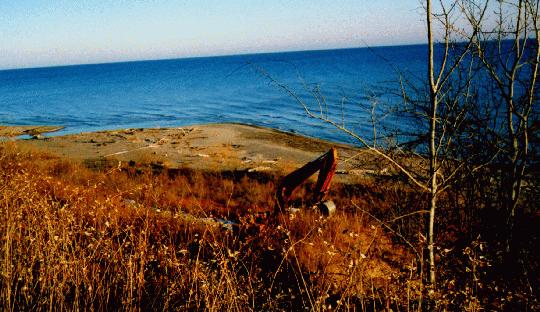 |
View from above. This is the new path as seen from the railway tracks above the construction. The path was constructed close to the bottom of the railway slope. The beach seen here was considered for naturist use but it is highly visible from all angles so the idea was scrapped. (Size:43KB) |
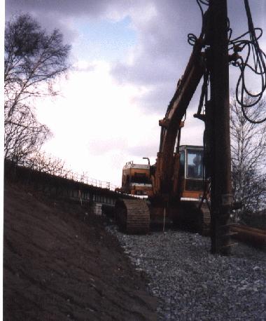 |
Bulldozer on path. This is the bulldozer that is being used to construct the path. You can see the railway bridge in the background. Photo courtesy of Fred B/Toronto. (Size:30KB) |
 |
The view from the main beach. The path being constructed is barely visible from the main beach which is south of the naturist beach, you can see the bulldozer in the distance. (Size:43KB) |
 |
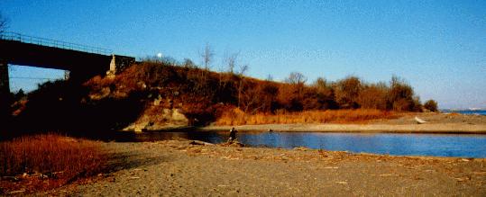
The railway bridge before construction. The area to the left of the railway bridge is in it's natural state before construction. Picture below is during construction. (Size:43KB) |
 |
The train crossing the railway bridge. It's very dangerous to cross the bridge. As you can see the passengers on the train have a full view of the beach south of the naturist beach. The naturist beach is a bit more secluded from the train due to some trees that hide the beach. Photo courtesy of Fred B/Toronto. (Size:22KB) |
 |
The railway bridge during construction. The area to the left of the railway bridge is under construction with the new road seen with a lot of gravel on it. This road will be used for heavy construction vehicles at the current time. (Size:43KB) |
 |
The naturist beach is across the creek. The beach is accessible by climbing down from the railway tracks or wading across the creek. It is not an easy beach to get to. (Size:43KB) |
 |
On the naturist beach. This is the east end of the naturist beach... after one of the cleanups. (Size:43KB) |
 |
The walking path under the railway bridge. This is the path being constructed under the railway bridge. On the other side of the railway bridge you can see the path down to the naturist beach. (Size:43KB) |
 |
A closeup of the path under the railway bridge. A lot of the original landscape is gone. It looks like they will be able to drive cars under the bridge when this is finished. Photo courtesy of Fred B/Toronto. (Size:44KB) |
 |
Graffiti under the train bridge at the top of the path down to the naturist beach. This bridge has to be traversed in order to get to the beach or you can wade through the creek. Photo courtesy of Fred B/Toronto. (Size:28KB) |
 |
The path down to the naturist beach which is very steep. Photo courtesy of Fred B/Toronto. (Size:36KB) |
![]()
Directions to Beechgrove Beach (Highland Creek Beach).
 |
Map of the beaches. Click photo to enlarge map. Note: This is a large photo. |
Drive EAST on the 401 to the eastern edge of Toronto going towards Pickering/Oshawa, exit at Morningside and head south until you get to Lawrence Avenue (just past Kingston Road). Turn left (east) and drive for several long blocks until you get to Beechgrove Drive. Then turn right (south).
Drive WEST on the 401 to the eastern edge of Toronto past Pickering/Oshawa, exit at Sheppard and turn left (west) along Kingston Road (Hwy 2). Turn left (south) almost immediately onto Port Union Road. Head south until you get to Lawrence Avenue and turn right (west). Drive for about 5 minutes until you cross a very large bridge, Beechgrove Drive is the road just on the other side of the bridge. Then turn left (south) on Beechgrove.
Follow this residential road (note that the speed limit is 40 km and I have seen police with radar there). It curves to the left and then again to the right continuing south over a railway tracks with a water treatment plant on the left.
Turn right into a large parking lot. The sign says: "East Point Park". Park your car there. The beach is a 10 - 15 minute walk from your car.
By public transit, take the subway and rapid transit to the Lawrence East station. Bus 54A goes out east along Lawrence. Ask the driver to point out the stop which is at the end of Beechgrove Drive. You'll have to walk about 1 km (15 minutes) to the beach.
Walk to the right of the water treatment plant where you will see a newly constructed gravel road which leads down to the water front. Follow this road down all the way to the newly constructed metal bridge that goes UNDER the railway tracks or you can walk along the beach, east.
To go over the tracks: This is not advisable as it is illegal to cross the train tracks. The tracks are railroad private property and people have gotten tickets doing this. Do so at your own risk!! The trains are fast and someone was hit by a train in 2001.
To cross the creek via the water: Go to the metal bridge and follow the path towards the water. At the water you will see a long sandbar jetting out to the right from the other side of the creek. The area to the RIGHT of the sandbar is up to your thighs. If you go straight ACROSS to the sandbar, you will get a LOT wetter {grin}. Follow the sandbar to the beach.
The beach we use is halfway down and behind the bushes. It is very difficult to see if anyone is there until you trip over them as it is hidden from view. We like to keep all nude people east of the bushes as the police will NOT bother us if we stay out of view of the train. They have been to the beach with no problems this year. If you tan nude in view of the train or on the west beach, you might get a ticket. In order to keep our beach we ask everyone to go to the nude part at the east end. Besides, that is where all the friendly people are :-)
There are people there every weekend and during the week in the afternoon and early evening.
Enjoy!
![]()
Beechgrove Photos - September & October 1998.
 |
Beechgrove Beach, September 1998. (Size:49KB) |
 |
Beechgrove Beach, October 1998. (Size:19KB) |
 |
Beechgrove Beach, October 1998. (Size:49KB) |
![]()
An Invitation to Comment on the Environmental Assessment for the Port Union Waterfront Improvements for the City of Toronto - January 1999.
 |
Click on the picture to display the information regarding the environmental assessment. (Size:91KB) |
![]()
Beechgrove Commentary - July 23.
Information provided by Fred B/Toronto.
Despite all the doom and gloom reports from last fall and this spring, Beechgrove's death has been wildly exaggerated.
This summer got off to an early start - in May - and the beach has been seeing increasing usage ever since.
Although the winter and early spring storms have reduced the beach size, there are still lots of sunning areas. The walk into the water is even nicer now that you can walk out more than 50 ft and the water is still only up to your waist. The hot whether has helped to warm things up nicely.
Over the last few weekends there have been many people enjoying the quiet atmosphere, the warm sunshine, and best of all - no gawkers.
Yes, the construction of last year has forever changed the area west of Highland Creek, but now it is a little harder for the casual hiker (gawker) to come over to our beach east of the Creek.
Those of us in the know will cross over Highland Creek where it empties into the lake. Don't go straight through the creek, go out into the lake to the sandbar and walk along it. It's quite shallow. For the braver souls, there is a hole cut in the fence near the new bridge at the corner, or walk along the tracks from the parking lot. Remember, trains are fast and you do so at your own risk.
This year, we are staying east of the clump of bushes and trees about half way down the beach. This is a nice area that is hidden from view from the new roadway. We have not had any harassment this year in this area. If you are new to the beach, just say Hi to anyone in this area and join us. Mostly we are there on weekends, but sometimes late in the day during the week too.
Please continue to support the beach by opposing the waste of public funds for the most expensive waterfront trail route that goes south of the tracks and requires the dumping of thousands of tons of fill into the lake. This route will destroy our beach. We can make a difference.
In the meantime, join us for a relaxing day.
![]()
At the beach on May 16, 17, 18.
Information provided by Ron Schout.
A good number showed up this long weekend (May 16,16,18) to find the "new Beechgrove nudist beach".
At first it might have been slightly intimidating with the new path but the nudists found that this was educational for the passersby. Pamphlets were left at the bridge where people had a pretty good view of the beach but there was no one that seemed to be annoyed. A few textiles came over for a walk through the beach and several went to the most westerly point for BBQ's and such but accepted the nudity on the beach.
It seemed that over the course of the weekend that there was good variety of nudists on the beach. There were some families, some couples, and of course mostly men. There was no police seen at all. With the fence up along the RR tressle it makes it almost impossible to cross the tressle, the only real way over is through the creek (which was very warm) and of course the police would have to come that route also or by boat.
I also feel that with the result of last year in court, the police may have ran out of by-laws to charge us under. There is still the criminal code, but that would involve a lengthly court case and with Wreck Beach and Crystal beach both setting precident, it would be difficult for them to convict anyone for the mere purpose of sunbathing in the nude.
This coming weekend according to the weatherman is to another great sunbathing weekend. There are many that have plans on returning. Join in.
![]()
Short letter to send regarding the Port Union Waterfront Improvement Project
Information provided by Ron Schout.
We are making a difference in the struggle for Beechgrove.
Thanks to all who have written, called or emailed your thoughts.
I have been vocal about the nudist issues that affect us at the beach and they are listening! At the last public meeting, a new proposal was presented that would NOT cross the sunbathing beach. The environmental assessment concludes on March 19. All submissions must be received by then.
For more information, please visit:
http://www.ene.gov.on.ca/envision/ebr/ea/english/index.htm
This is a sample letter for those that do not regularly attend a clothing optional beach but are in support of one. I would encourage you to get as many friends that are aware of your status of being a nudist and get them to sign one of these and then fax it to Larry Field at: (416) 661-6898
Send to the following list:
Mr. Larry Field
Toronto and Region conservation Authority
5 Shoreham Drive
Downsview, Ontario
M3N 1S4
Phone: (416) 661-6600
Fax: (416) 661-6898
Mr. Frank Faubert
City of Toronto Councillor
Metro Hall
55 John St, Ste. 206
Toronto, Ontario
M5V 3C6
Phone (416) 392-4008
Fax: (416) 392-4120
Mr. Ron Moeser
City of Toronto Councillor
Metro Hall
55 John St, Ste. 206
Toronto, Ontario
M5V 3C6
Phone (416) 392-1373
Fax: (416) 392-7429
Mr. Steve Gilchrist
Member of Provincial Parliament
Member, PC - SCARBOROUGH EAST
17th Flr
777 Bay St
Toronto, ON M5G 2E5
Phone: (416) 585-6940
Fax: (416) 585-7320
Mr. John McKay
Member of Parliament
4630 Kingston Rd, Unit 12
Scarborough, Ontario M1E 1K8
Phone: (416) 283-1226
Fax: (416) 283-7935
---------------------------------------
March 12, 1998
Re: Port Union Waterfront Improvement Project
City of Toronto - Highland Creek to the Rouge River
Environmental Assessment Terms of Reference
For over 20 years now the beach at the end of Beechgrove Drive has been actively used by naturists for the purpose of clothes-optional sun tanning and swimming.
With the new plans for the Lake Ontario Waterfront Trail this beach and its use is endangered. This Trail will have a negative environmental impact on the beach and on the natural vegetation. This vegetation offers shade and screening for those enjoying an afternoon of nude sun bathing and swimming.
According to the Toronto and Region Conservation Authority (TRCA) they wish to develop safe public access to the waterfront. I believe that this measure of safety can be provided while safeguarding the natural environment and the current clothes-optional beach use at an affordable cost.
The naturist use of this beach cannot be argued at this time as precedence has been set at other clothing-optional beaches in Canada.
I have visited the area many times to enjoy the natural and rusticbbeauty and believe that this beach is well-suited for nude sun bathing and waterfront recreation.
The TRCA is proposing three alternatives for the Waterfront Improvement Project between Highland Creek and the Rouge River:
1. Do nothing - leave the areas as it is now;
2. Minor modifications to provide safe waterfront access to the public with the trail proceeding north of the railway tracks; and
3. Waterfront corridor south of the CN Rail Lines.
I support Alternative 2 with some modification.
The existing situation is dangerous to the public when crossing the railway tracks to get to the waterfront. However, the last alternative would do the greatest amount of damage to the environment. Waterfront access along the Waterfront Trail should not come at any cost.
Original plans included a proposed route south of the railway tracks at the water's edge. This route would require many thousands of truckloads of fill to stabilize the shore. The TRCA has estimated that the actual volume of fill required would be approximately 38,000 cubic metres. The environmental impact of this construction traffic would be enormous.
The TRCA had proposed this "waterfront only" route in the public meetings. Due to public resistance, the proposal now includes an alternative route that proceeds north of the railway tracks at the west end of the study area.
The TRCA should investigate routing the walkway between the railway tracks and the landfill site on the north side of the tracks. This path appears wide enough to support a walkway from Highland Creek east to the first railway underpass at Port Union road.
This route will provide for public safety at the railway tracks by using the Highland Creek Trail pedestrian underpass. In addition, it would be less environmentally damaging, less expensive, and provide waterfront access on the west side of Highland Creek to the East Point Park beaches.
For these reasons, I support a modified Alternative 2 route.
Sincerely,
Your name and Address
![]()
Public Meeting
PORT UNION WATERFRONT DESIGN OPEN HOUSE.
Information provided by Fred B/Toronto.
Public Meeting - March 4th, 1998.
The future of Beechgrove beach is in jeopardy.
This beautiful stretch of isolated lake front may be lost if plans to construct a waterfront trail proceed. These plans include building a road across the beach that has been used for decades for clothing optional sunning and swimming.
The road would permit construction traffic to the trail location that will require thousands of truckloads of fill. This construction is expected to take between 5 and 7 years.
The Toronto and Region Conservation Authority is seeking permission from the Ministry of the Environment to proceed with their plans for the waterfront trail from Highland Creek to the Rouge River. They must receive approval before proceeding with any construction that may endanger the environment.
Once this approval is obtained, it will be just about impossible to stop or alter their plans.
The deadline for submissions is March 12, 1998.
It is the intent of the Authority to undertake the Environmental Assessment as proposed in the following schedule, subject to timing modifications as warranted:
- Terms of Reference posted on the Environmental Bill of Rights (EBR) for a thirty day public review period - February 1998
- Minister's Decision on the Terms of Reference - March 1998
- Environmental Assessment Public Meetings - March 1998
- Draft Environmental Assessment circulated for agency review - April - May 1998
- Submission of Final Environmental Assessment document to the Ministry - May 1998
- Ministry of Environment - concurrent public and agency review - May - August 1998
- Minister's Decision regarding the Environmental Assessment - Summer 1998
Please plan to attend the public meeting or write directly to the Ministry of the Environment.
The public notice of this meeting follows:
------------------------------------------------------------------------------
PORT UNION WATERFRONT DESIGN OPEN HOUSE The Toronto and Region Conservation Authority (TRCA) invites you to participate in a Public Meeting/Open House to discuss the Port Union Waterfront Improvement Project Environmental Assessment. The TRCA is looking to undertake waterfront improvements from Highland Creek to the Rouge River. A Terms of Reference for this Project has been submitted to the Ministry of the Environment as required by the Environmental Assessment Act. This Open House will provide an opportunity for the public to comment on the three design options for the waterfront that are to be included within the Environmental Assessment, and discuss the potential environmental effects and proposed mitigation measures for each.
Date: Wednesday, March 4, 1998
Time: 6:30pm Open House
7:15pm Presentation
Location: Sir Oliver Mowat Collegiate institute
Lecture Hall and Gym
(Port Union Road and Lawrence Ave. East)
Your ideas and participation are sincerely welcome and are critical to realizing your vision for the waterfront.
The Terms of Reference was posted on the Environmental Bill of Rights Registry on February 12, 1998. Please provide your comments with 30 days. You can view the Terms of Reference HERE.
or contact us at the number below to receive a copy.
If you are unable to attend the meeting and would like further information, please contact:
Larry Field, Waterfront Specialist
Toronto and Region Conservation
5 Shoreham Drive, Downsview, Ontariio M3N 1S4
Telephone: (416) 661-6600, ext. 243
Fax: (416) 661-6898
-------------------------------------------------------------------------
You may contact the Ministry of the Environment:
Environmental Assessment Branch
250 Davisville Avenue
5th floor
Toronto, Ontario
M4S 1H2
Phone: (416) 440-3450
Fax: (416) 440-3771
![]()
Comments on Construction
Comments on the construction along the beach by Fred B/Toronto.
Report 1 - December 14, 1997
I went for a walk at the beach today and was shocked to find some dramatic changes.
There is now a road from the parking lot, along the treatment plant, sloping down to beach #1 past the rocks and continuing at the back of the beach until it nears Highland Creek where it slopes up to the top of the original trail. It is poised to continue across the creek to beach #2 by bridge where similar destruction will occur.
This road is built with a large stone bed that will support heavy construction trucks. The only purpose I can see is to prepare for the waterfront trail that will be built next year. This trail will link East Point Park (where the beach is located) to Rouge Park by a pedestrian/bike path along the waterfront.
The damage to the natural surroundings of beach #1 is horrendous. It will take years for the vegetation to recover - if ever.
This road was built to support a construction project that has NOT cleared environmental approvals and that does NOT have any funding.
I urge everyone to take a walk down there to see the changes as soon as possible.
Ron S. and Dave F. have planned a meeting for early/mid January to discuss strategies and plans for next year. The road is definitely a factor.
Report 2 - December 16, 1997
I phoned the Director of Metro Parks Construction today.
The work that is being done is related to the completion of what is known as "Highland Creek Trail". This trail extends south from Colonel Danforth Park (Kingston Rd near Lawson) and follows Highland Creek to the lake front. The trail then goes underneath the railway tracks and joins East Point park.
It is not related to the Waterfront Trail and the public meetings that were held recently.
The road was put in to transport heavy equipment to the railway bridge. The road will be complete this year. At the bridge, supports will be placed for a walkway under the rail bridge and shore protection will be formed to protect the walkway from river floods. The whole project is expected to be completed in May/June '98.
The road will eventually be 3.5 metres wide and the existing large rocks will be covered with smaller stone and a finishing hard surface - probably limestone. This type of path is common to Metro Parks and used across the city.
Vegetation will be replanted and the area will eventually return to normal.
However, this is what WILL happen and the amount of destruction that WILL occur when the Waterfront Trail proceeds across beach #2.
The Waterfront Trail project across beach #2 and ending at Rouge Park will take about 8 to 10 years! I don't know how much of this time will require access from East Point and how much will occur from the other end.
Report 3 - December 22, 1997
I have submitted the following article to one of the local papers - the Bluffs Monitor.
-------------------
I went for a walk at East Point Park on the weekend and was shocked to find some dramatic changes to our waterfront. East Point is at the foot of Beechgrove Ave., extending from approximately Manse Rd. to Highland Creek. It is one of the last areas of the Scarborough Bluffs that is still rustic and in a very natural state.
Not any longer! Recently, a portion of the Bluffs has been bulldozed away to make room for a road down to the beach. This destruction of the natural surroundings continues along the beach until it nears Highland Creek where another chunk of the Bluffs has been torn away to allow the road to slope up to the top of the original trail. All natural vegetation has been flattened along the way.
According to Frank Kershaw, Director of Construction at Metro Parks, this road was built to allow heavy vehicles access to Highland Creek so that a pedestrian underpass at the railway bridge can be built. This is all part of the Highland Creek Trail that runs south from Colonial Danforth Park at Kingston and Lawson Roads. The Trail is expected to be completed in May/June '98.
While this project has merits and will permit enjoyable use of the Highland Creek area, why this intrusive method was selected is not known. An access road is already available at the railway bridge from the nearby treatment plant. The top of the bluffs had a natural path along it and minimal backfilling would have been required to widen it to the appropriate size.
Instead, this road has been built with a large stone bed that will support heavy construction trucks. The only reason for this route that I can see is to prepare for the waterfront trail that will be built next year. Eventually, this trail will link East Point Park to Rouge Park by a pedestrian/bike path along the waterfront.
Again Metro Parks has chosen a more expensive and difficult construction method. Current plans will require thousands of truckloads of fill to be dumped into the lake to permit the path to continue on the lake side of the GO tracks. These trucks will have to follow this new road at East Point and continue across Highland Creek to another stretch on unspoiled beachfront.
An alternative route would have been to use an existing trail along the north of the tracks until the natural shoreline permitted water's edge access. Current plans already show beachfront access from the foot of Port Union Road that is near where the underpass would be. The Waterfront Trail project across Highland Creek and ending at Rouge Park will take about 8 to 10 years.
I am opposed to the wholesale destruction of the Scarborough Bluffs for a walking trail. What's the point of having a scenic trail when the scenery has been destroyed? Part of the Scarborough Bluffs has been bulldozed away without public consultation. The road has been built with no regard for natural beauty.
I have lived in Scarborough for 16 years and wish to keep this area attractive to residents and visitors. Why do the Bluffs have to become a manicured park and lose their wild nature?
Comments on the construction along the beach by Phil M.
While I think we need to react to the recent events at Beechgrove, I think it's important not to over-react!
When Fred and Dave and Ron and I were at the Port Union trail meeting recently, it was apparent to me that major destruction would take place in order to create the trails. I also knew that the Highland Creek trail was underway, but that may have come from an off-line conversation with one of the staff. So as soon as I heard that they had built a bulldozer trail down to the beach I knew it was to aid the building of the Highland Creek trail up to Col Danforth Park, not about someone running amok ahead of permits to build the waterfront trail.
From the architects drawings, it was apparent that the total character of the existing beach would be destroyed to urbanize it and make a new trail. I don't think that's all bad. The existing vegetation at Beach 2 is scrub brush, inhospitable and impassable, containing poison ivy, sumach and small trees that can withstand the heavy weather. It does little in my mind to contribute to the usefulness of the beach, and certainly is unlikely to be home to anything worth saving. The tress at the top of the embankment do a little to obscure the view from the GO train but not much.
The architect's drawings showed a cross-section of their plan for the beach which unfortunately does not seem to be in the handout. We'll put what we do in this Beechgrove section soon.
What I remember about what they told us is that they consider this section of the beach one of the most rugged and exposed in the whole trail. Indeed, just past Beach 2 there is no beach at all; only the railroad embankment holds the lake back. Their plans change all that.
They intend to strip the vegetation right back to the cinders supporting the monumental train embankment. Near the foot of the embankment they will build a path well elevated from the beach which they can protect from erosion and ice. It will be slightly more than a metre wide and probably be of limestone (allowing bicycles and wheelchairs but perhaps not skating). In the areas where there is no beach at all, this will be a massive construction requiring heavy equipment and thousands of truckloads of fill, which will all drive right across existing beach 2.
Between the top path and the beach will be an area of vegetation on the slope down. It is possible that in the Beechgrove area they will provide heavy vegetation since they did show some concern about protecting beach privacy in this area, indicating they knew the existing use of the beach was for nude sunbathing. The 'beach privacy' part was written; the 'nude' part was verbal.
The path design allows for periodic viewing areas where there are railings etc. and places for people to stop and view the beach and even come down to the beach.
On the beach itself, where there is beach, they plan another trail which is vulnerable to the weather and likely will be little more than hardpacked sand and will require maintenance.
One perspective on this is that this will make the beach much more attractive and pleasant. Another is that, without the privacy, nude use is forever lost.
My personal view is that the current situation was unlikely to lead to a formal nude use of the beach at all. Access to Beach 2 was either illegally across the railroad bridge and down dangerous slopes, or to Beach 1 which is totally exposed to view from the commuter trains no matter how much money you spend on it. With the continued police harassment which seems to at least been likely to have derived from political puttering, the numbers using the beach were just not going to grow.
That's all hindsight.
The Waterfront trail is a huge political force in Ontario, and it is unreasonable to suggest that anyone could stop the placing of a waterfront trail right across the province; most definitely the shoreline of Lake Ontario will be done no matter what.
Thus, there will be a bridge across Highland Creek between Beach 1 and 2.
There will be trail access down to the beach, including handicap and bicycle access.
This will make the beach more accessible than any free beach I know of, other than Haulover from which I have just returned, where there is a God-given privacy barrier in the form of a sea-grape covered high dune between the beach and the paved walkway, making it possible for the city to claim that people seeing nude bodies were at least warned.
I see the biggest problem with the trail being the increased public exposure leading to making it politically difficult to permit nude use.
I propose two actions:
1) We campaign hard to have significant privacy built along the trail in the Beechgrove Area making the casual user either unaware of the nude use or at least able to ignore it.
2) We begin, starting in 1998, to find a way to get large numbers of nudists using the beach, which we can now easily walk down to, in the hope that we improve our ability to show existing use. I hate to say it, but if we have to, we may have to resort to the use of G-strings. It has been declared constitutionally legal in Canada for both men and women to appear without tops in public. We can make them seem ridiculous for harassing us if what we are discussing is the size of pouch or triangle. I'm really of the opinion that we have to give the authorities a little room here. Toronto is home to the most conservative of the country's people. Last month, finally, by referendum the last 'dry' section of Toronto was eliminated! The difference between nude and legal is significant in court. Don't misunderstand me, the difference between nude and pouched is huge to me! But, if at least once in a while they went to bust us and were wrong, it would give them something to say forever to the complainants.
3) We find a way to get the police to quietly desist from harassing us. I believe they would leave us alone if they were not directed to go there. Even then, with the proper coaching, they can use their discretion. Remember, the political situation in Toronto just changed dramatically. Toronto is now one, Scarborough no longer exists, the local councillor is one of 52 for the whole seething mass. Perhaps, with luck, we're in better shape politically.
Anyhow, this isn't all bad. I think it has good prospects!
![]()
Copyright © 1997 - 2012 NetNude Inc.